
Find and analyze drilling wells
Search an existing field
- Open Drilling and choose Find wells by → Existing field.
- Select an Existing field and click Find wells.
- Review Drilling wells / projects (API10). The first 10 projects flagged with reports are initially selected; choose up to 25.
- Click Analyze drilling to load reports and available paleo/casing histories.
Search near a block
- Choose Find wells by → Nearest to block and select a Reference block.
- Set Number of nearest wells (default 10, maximum 25) and Minimum spud year (default 2002).
- Optionally use Find nearest wells to preview the ranked selection, then click Analyze drilling. Analyze repeats the nearest search with fresh data.
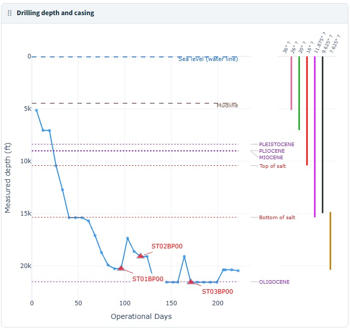
Navigate and adjust the chart
| Control | How to use it |
|---|---|
| Previous well / Next well / Well selector | Move through the submitted API10 projects without rerunning analysis. The depth curve, casing and reference overlays follow the current well. |
| Show operational days | On by default: accumulates valid report durations and omits unreported gaps. Turn off to show the full history on elapsed Calendar Days. |
| Sea level and mudline | Show or hide the current project’s available water-reference depths. |
| Paleo tops | Show or hide geological reference lines and their labels. |
| Paleo detail | Choose Series, Subseries or Stage. |
| Proposed casing | Off by default. Adds dashed proposed casing to the recorded solid casing intervals. |
An API10 project groups the first ten API digits; the full API numbers identify individual sidetrack/bypass branches. Analyze includes the selected projects’ branches, including branches assigned to other fields.
Read depth, branches and casing
Measured depth (ft) increases downward. Lines connect recorded report observations. Missing or invalid depths break the curve; decreases and intermediate flat periods are retained.
Operational Days adds each valid report’s inclusive duration. Overlapping reports each contribute their duration, so this is not a count of unique calendar dates. Calendar Days uses elapsed time from the earliest valid report start, including gaps. Day 1 belongs to that report origin rather than necessarily the spud date.
Red triangles and STxxBPxx labels mark report-based branch transitions. Their anchors are not proven kickoff depths or dates. A terminal constant-depth tail is shortened in the operational view; full observations remain in downloads.
The right-hand casing panel shares the measured-depth axis. Diameter labels are inches; horizontal spacing only separates strings and has no time meaning. Combined casing intervals span recorded branch/report observations by diameter and type. Proposed dashed strings do not establish installed casing.
Paleo lines are observed reference depths rather than confirmed formation tops. Salt bounds mark the shallowest and deepest recorded salt observations.
Use the drilling workspace
Drag a panel header onto another panel to swap their positions. For keyboard operation, focus the header and use the arrow keys. Layouts stay with the current browser session, and panels stack on smaller screens. Hover over chart observations for details; use chart zoom and legend controls where available.
Tables and CSV downloads appear below the chart workspace. Expand the relevant table to see its contents. The dashboard’s method and data-quality guide is at the bottom.
The Drilling wells map shows submitted wells and available directional paths. The currently displayed well’s layers and reference overlays follow navigation. Panels with no usable drilling or casing data display an empty state; the project remains navigable.
Nearest searches rank great-circle distance from the block’s recorded point to a project’s closest usable branch surface location. This is not distance from a block boundary or a bottomhole. Minimum spud year tests the project’s earliest valid branch spud year, so a newer sidetrack does not make an older project eligible.
Inspect reports and export histories
Expand Current well and coverage, API branches and sidetrack starts, Drilling report observations, Paleo observations and reference depths, or Casing intervals and source observations. These sections provide current-well details and CSVs, including source observations and full report histories.
Nearest searches also provide Nearest wells to the reference block with rank, distance and search metadata. Review Drilling guide, method and data quality for the submitted selection’s exclusions and assumptions.
Resolve missing or unexpected results
- Field/project or nearest-search input changes clear previous analysis results. Click the relevant Find or Analyze action to load the revised selection.
- A nearest well can have valid coordinates and spud history but no usable drilling reports. Try another project or broaden the nearest search.
- Projects without a usable early spud date cannot qualify for the minimum-year search. Lower the minimum year or choose another block when no matches are available.
- Paleo and casing sources can fail independently while drilling remains usable. Review the source message and rerun Analyze to retry.
- The field-development cutoff does not apply here. Reports use their recorded dates, and availability does not prove a complete drilling history.