Wells & Boreholes

The Wells/Borehole database includes all the data on the well related to the borehole itself. From the Boreholes area on GOMsmart, you can easily access data on: Well Tests, Production, Well Log images, Completions and Paleo.
Data Updates
The Wells database is updated weekly. New wells will appear on all GOMsmart maps within 1 hour of an BOEM update.

Database
The GOMsmart Well database includes data mined from BOEM and ESA’s own data research(*).
- Well API Number
- Well Name
- Well Name Suffix
- Well Operator Code
- Well Field Name
- Well Spud Date
- Well Bottom Hole Lease Number
- Rig Kelly Bushing Elevation (feet)
- Well Bottom Hole Measured Depth (feet)
- Well Bottom Hole True Vertical Depth (feet)
- Well Surface North-South Distance
- Well Surface North-South Code
- Well Surface East-West Distance
- Well Surface East-West Code
- Well Surface Area Code
- Well Surface Block Number
- Well Bottom North-South Distance
- Well Bottom North-South Code
- Well Bottom East-West Distance
- Well Bottom East-West Code
- Well Bottom Area Code
- Well Bottom Block Number
- Well Total Depth Date
- Well Status Date
- Well Type Code
- Well District Code
- Well Status Code
- Water Depth (feet)
- Well Surface Longitude
- Well Surface Latitude
- Well Bottom Longitude
- Well Bottom Latitude
- Operator
- Well Surface Area + Block Number*
- Well Bottom Area + Block Number*
- Surface Area + Block + Well Name*
- Bottom Area + Block + Well Name*
- Mapping Longitude*
- Mapping Latitude*
- Number of Completion Intervals*
- Number of Completions*
- Number of Tests*
- Number of Paleo Picks*
- First Production Date*
- Last Production Date*
- Spud Date
- Well Total Depth Date
- Well Status Date
- Well Cumulative Oil Prod (bbls)*
- Well Cumulative Gas Prod (Mcf)*
- Well Cumulative Gas Prod (BOE)*
- Well Cumulative Water Prod (bbls)*
- Well Cumulative BOE Prod (BOE)*
- Well Last Calendar Year Oil Prod (bbls)*
- Well Last Calendar Year Gas Prod (Mcf)*
- Well Last Calendar Year Gas Prod (BOE)*
- Well Last Calendar Year Water Prod (bbls)*
- Well Last Calendar Year BOE Prod (BOE)*
- Well Cumulative Gas-Oil Ratio (Mcf/stb)*
- Well Classification*
- Velocity Survey Flag*
- Number of Well Logs from BOEM*
- Directional Surveys: real or pseudo*

Maps
Easily create a custom map showing the specific Well or area you select, or utilize one of the 13 standardized maps from the GOMsmart map library. All maps are automatically updated and show only the most current data.

Charts
Single-Feature Charts:
There are 12 production charts available for Wells. Oil, Gas, Water and BOE data are available annually or monthly. Charts can be linear or logarithmic.
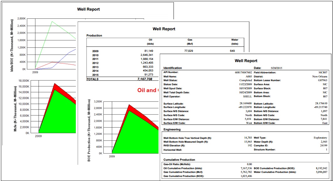
- Well Oil Annual Production History
- Well Gas Annual Production History
- Well Water Annual Production History
- Well BOE Annual Production History
- Well Oil and Gas Annual Production History
- Well Oil, Gas, Water Annual Production History
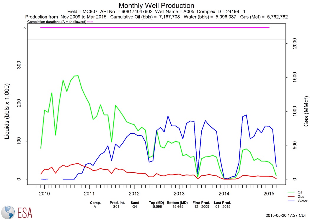
- Well Oil Monthly Production History
- Well Gas Monthly Production History
- Well Water Monthly Production History
- Well BOE Monthly Production History
- Well Oil and Gas Monthly Production History
- Well Oil, Gas, and Water Monthly Production History

Reports
Single-Feature Reports:
There are 12 reports for single Wells.
- Summary/Production Report
- Well Test Report
- Completion Report
- Paleo Details Report
- Paleo Summary Report
- Well Production Data (as CSV file)
- BHP Survey (BOEM Website)
- APD/AST/ABP Report (BOEM Website)
- Application for Permit to Modify (BOEM Website)
- End of Ops Report (BOEM Website)
- Well Activity Report (BOEM Website)
- Well Info Systems (BOEM Website)
Multi-Feature Reports:
Easily create reports with individual Well data for multiple Wells combined into a single report. There are 3 types of reports: All Wells, Development Wells and Exploratory Wells.